
Paddle The Creek
While continuous paddling of the full Fishkill Creek due to dams and rapids, the creek offers several beautiful sections to enjoy in a kayak, canoe or with a paddle board. Please find descriptions and maps below. Some safety tips first.
General Safety
Before any paddle, make sure someone on land knows your planned route and approximate timing. Consider not paddling solo, especially on unfamiliar sections.
Always wear your PFD/ life vest — not just bring it. Carry a whistle, water, and wear water shoes.
Creek conditions can change within days. A submerged stump can appear where none existed recently, and a newly downed tree can block passage entirely.
Paddle upstream: unless you paddled a particular section within the last couple days, or have a reliable recent report on conditions, consider starting your paddle going upstream first. This way, if you encounter a serious obstacle you can simply turn back.
Cold water: Even in warmer months, Fishkill Creek water can be cold enough to cause cold shock or hypothermia if you capsize. This is especially true in spring.
Strainers: On the downstream leg, be especially alert for strainers — downed trees or log jams that allow water to flow through but can trap larger objects, including boats and people. These are among the most serious hazards on a creek paddle.
Wading: Avoid wading in fast-moving water. Even knee-deep current can knock you off balance and trap your foot in debris. If you do capsize in moving water, float on your back with feet pointed downstream rather than attempting to stand.
After rain: The creek can rise fast after significant rainfall upstream. If there has been substantial rain in the past 24–48 hours, conditions may be dramatically different than they appear locally. Use extra caution or postpone.
Dams: do not approach any dam, extremely dangerous.
In 2026 Fishkill Creek Watershed Alliance partnered with Mid-Hudson chapter of ADK to open passages in log jams to make it possible to paddle more sections of the creek. For more info and upcoming volunteer work parties check our OPEN CREEK page
Hudson River
Tides: Hudson River at the Fishkill Creek estuary is tidal. Check tide tables before you go and plan your trip accordingly.
Boats types: certain weather conditions on Hudson River can make it hard to paddle short recreational kayaks, canoes and paddle boards. Longer touring / ocean kayaks tend to perform better.
Dennings Point: The area near the tip of Dennings Point can be particularly challenging, with choppy water, cross-currents, and exposure to westerly winds. Plan accordingly and be prepared to adjust if conditions are rough.
Wind: Strong winds on the Hudson can make paddling very difficult. Check the forecast before launching.
Thunderstorms: Do not paddle on the Hudson River if there is any chance of thunderstorms. Get off the water immediately if a storm develops unexpectedly.
Boat traffic: Be alert to motorboat and barge traffic. Wakes can be surprisingly large and disorienting, particularly for paddlers accustomed to flatwater conditions.
Plan your return: Remember that you will be re-entering the Hudson on the way back, potentially in different wind and tide conditions than when you launched. Conditions on the river can shift significantly over a few hours — factor this into your timing.
DISCLAIMER: The paddling information provided on this website is for general informational purposes only. Fishkill Creek Watershed Alliance (FCWA) makes no representations about current water levels, creek conditions, hazards, or the suitability of any route for any individual paddler. Conditions can change rapidly and without notice. Paddling involves inherent risks, including serious injury or death. By using this information, you accept full responsibility for your own safety and the safety of those in your group. Always exercise your own judgment, obtain current local conditions before launching, and paddle within your skill level. FCWA assumes no liability for any loss, injury, or damage resulting from use of this information.
Questions? Noticed something on your excursion? Want to share current conditions update? Please get in touch.
-
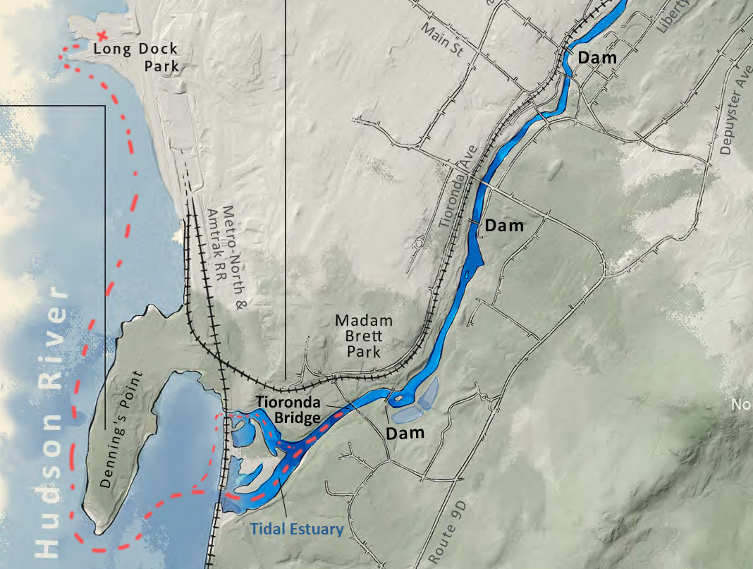
Long Dock - Fishkill Creek Estuary
Beautiful paddle starting on Hudson River past Dia Beacon, around the iconic Dennings Point State Park, under the MTA railroad bridge and into the tidal mudflats of Fishkill Creek. Enjoy the drift wood structures along the shore, stretch your legs at the Dennings Point, observe abundant wildlife, connect to the human history of these waters.
Launch at Long Dock Park in Beacon. Free parking, restroom.
Finish at old Tioronda Bridge before the first set of rapids, return to Long Dock.
Distance/Time: about 5 miles round trip. A leisurely family paddle can take 2-4h or so for the round trip. Faster paddles do in an 1h or so.
Tide timing: Plan your launch around the tides: many paddlers choose to launch with the outgoing tide so the incoming tide assists on the return upstream leg.
MTA bridges: easier to access the downstream bridge; seasonal vegetation often blocks access to the upstream bridge.
Note: there may not be sufficient clearance under the bridge during very high tides — check tide tables before planning to pass underneath.
Emergency exit is possible at Dennings Point and Madam Brett Park.
It is not recommended as a solo route for anyone unfamiliar with open water conditions.
-
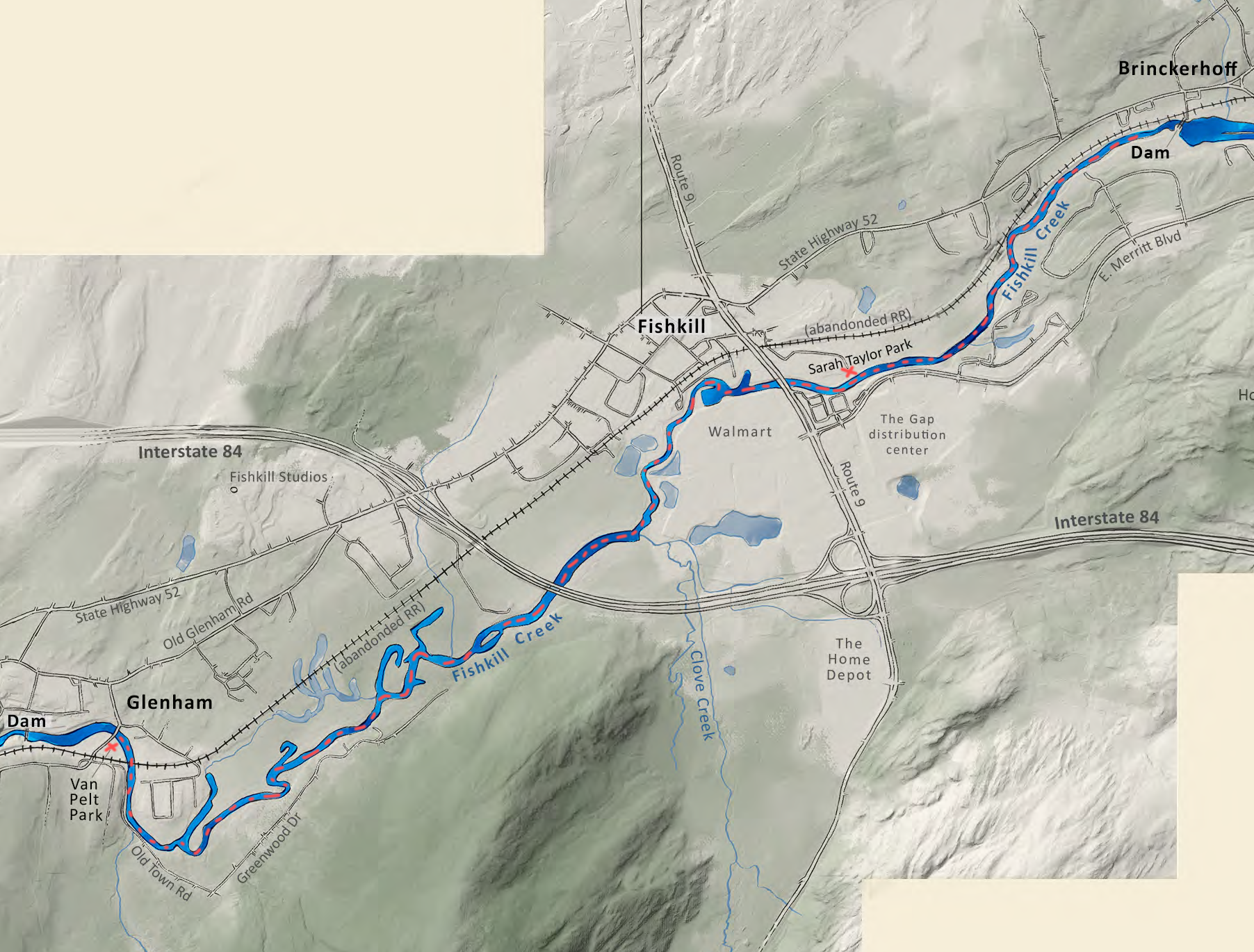
Jean Van Pelt Park - Sarah Taylor Park - Brinckerhoff Dam
Great weekend adventure route. Fishkill Creek is snaking through a mix of forested areas, single-family houses, and some bigger developments providing a unique perspective, great paddling and easy access.
Launch
Jean Van Pelt Park in Old Glenham. Park adjacent to the launch ramp, no restrooms.
Sarah Taylor Park in Fishkill. Parking is about 100 feet from the water; no ramp, grassy bank launch; park has porta potties.
Finish at either of the parks. Under favorable conditions it can be possible to paddle all the way to the Brinckerhoff Dam near Rt 52 & 82 intersection. No public launch there, return back to one of the parks.
Distance/Time: Van Pelt Park to Sarah Taylor Park - 3.5miles, Sarah Taylor Park to Brinckerhoff Dam - 1.5mile. Round trip can take several hours.
Notes:
Current can be fairly strong especially after rain, going upstream can take significantly more time than on the flat water.
Log jams and fallen trees possible.
A lot of land along the creek is private.
-
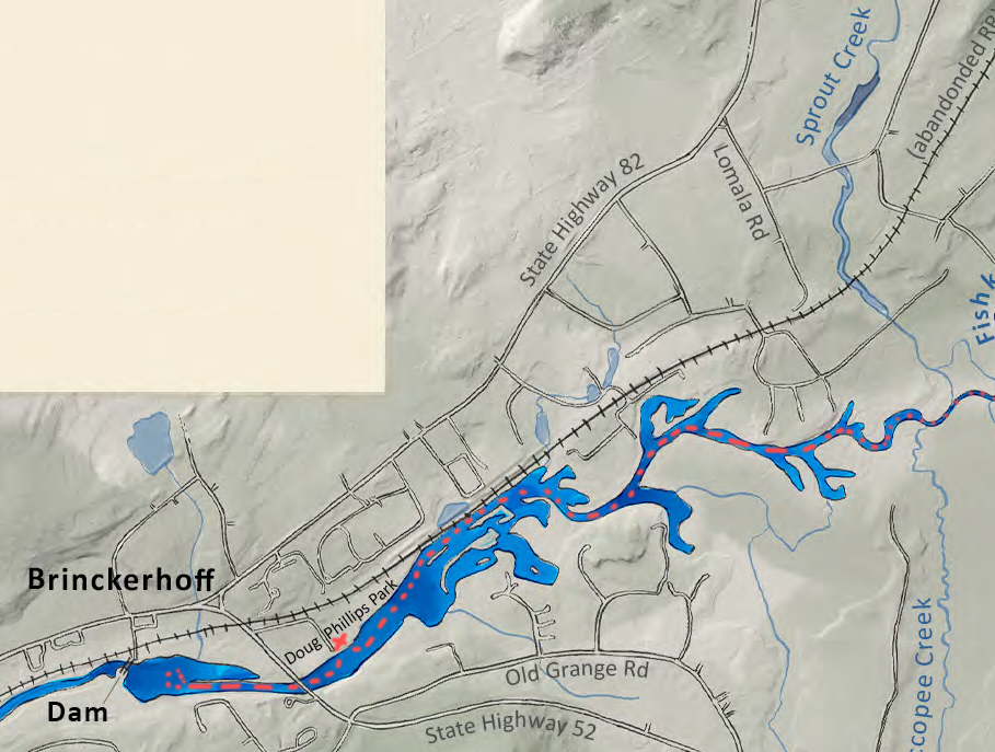
Doug Phillips Park - Sprout Creek - Hopewell Recreation
Creek paddling at its best. With just a handful of houses along the shore, this serene and beautiful stretch snakes through forest and wetlands. Sprout Creek and Wiccopee Creek confluence create a maze of small forested islands. Birds and fish abound.
Launch:
Doug Phillips Park in Fishkill/Brinckerhoff. Park adjacent to the launch ramp towards the back of the park. Porta potty on site.
Might be possible to launch at Hopewell Recreation Center and go downstream, very shallow.
Finish: Doug Phillips Park
Distance/Time: Doug Phillips Park to Sprout Creek confluence: ~1.5 miles one way. Sprout Creek confluence to Hopewell Recreation Center: ~5 miles one way. Most paddlers do the lower segment as an out-and-back from Doug Phillips.
Notes:
Some sections tend to become too shallow to paddle by July
Multiple logs jams above Sprout Creek as of May 2026.